|
|
Washington State's Olympic Peninsula Loop
P a r t T w o
Sea caves at Cape Flattery
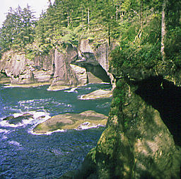 If time allows, a side trip to Neah Bay is a must. Just before US 101 turns south, take SR 113, which connects with SR 112, and head northwest to the fishing villages of Clallam Bay and Seiku. From here on the road hugs the scenic coastline along the Strait of Juan de Fuca and offers many opportunities for beachcombing and picturetaking. The village at Neah Bay is the heart of the Makah Nation. For thousands of years the Makahs have hunted and fished in the waters that cradle their ancestral home. To learn more about their native heritage visit their unique Cultural and Research Center - built in 1979 to house 500-year old relics and artifacts unearthed by archeologists at Ozette, their ancient whaling village at Cape Alava. It also features a full-scale replica of a cedar longhouse, as well as handcarved whaling and fishing canoes. Continue west along the Cape Loop Road to Cape Flattery, the most northwesterly point in the contiguous 48 states. From the lookout trail, visitors can view the ocean and nearby Tatoosh Island; watch for trail signs to the sea caves. Over 200 species of birds, including the tufted puffin, find refuge on the rocky headlands along the coast; there are a number of vantage points from the road that offer excellent viewing opportunities. At Hobuck Beach follow the Hobuck Beach Road to Sooes Beach and the National Fish Hatchery - fall is the best time to watch the returning chinook salmon. Before heading back out to US 101, drive out to Lake Ozette; from the ranger station hike 3 miles to Sand Point, one of the most beautiful wilderness beaches on the coast. If time allows, a side trip to Neah Bay is a must. Just before US 101 turns south, take SR 113, which connects with SR 112, and head northwest to the fishing villages of Clallam Bay and Seiku. From here on the road hugs the scenic coastline along the Strait of Juan de Fuca and offers many opportunities for beachcombing and picturetaking. The village at Neah Bay is the heart of the Makah Nation. For thousands of years the Makahs have hunted and fished in the waters that cradle their ancestral home. To learn more about their native heritage visit their unique Cultural and Research Center - built in 1979 to house 500-year old relics and artifacts unearthed by archeologists at Ozette, their ancient whaling village at Cape Alava. It also features a full-scale replica of a cedar longhouse, as well as handcarved whaling and fishing canoes. Continue west along the Cape Loop Road to Cape Flattery, the most northwesterly point in the contiguous 48 states. From the lookout trail, visitors can view the ocean and nearby Tatoosh Island; watch for trail signs to the sea caves. Over 200 species of birds, including the tufted puffin, find refuge on the rocky headlands along the coast; there are a number of vantage points from the road that offer excellent viewing opportunities. At Hobuck Beach follow the Hobuck Beach Road to Sooes Beach and the National Fish Hatchery - fall is the best time to watch the returning chinook salmon. Before heading back out to US 101, drive out to Lake Ozette; from the ranger station hike 3 miles to Sand Point, one of the most beautiful wilderness beaches on the coast.
Once back on the highway watch for signs to the Sol Duc Fish Hatchery where interpretive displays educate visitors about this important Washington resource. Then head west to either Railto Beach, gateway to the North Wilderness Coast, or to the village of La Push, on the Quileute Indian Reservation, where there is easy access to several scenic beaches. Offshore rocks along the coast lie within the Quillayute Needles Wildlife Refuge and the Washington Island Wilderness Area. Both offer sanctuary to birds and marine mammals and excellent wildlife viewing opportunities (visitors should remain at least 200 yards away). Before heading for the Hoh River Valley stop in Forks to chat with the locals at one of the friendly cafes, and visit the Timber Museum to learn all about their colorful logging history. Follow the Hoh Road along the Hoh River Valley (keep an eye out for Roosevelt elk) to the ancient rain forest, one of only a few temperate rain forests on the planet. From the Visitor's Center follow interpretive loop trails that take you into an incredible world where lush plant life seems to cover every square inch of space. Overhead is a living canopy of mosses, lichens, and ferns hanging from the branches of towering trees; underfoot is a forest floor carpeted with spongy ground covers.
Ruby Beach
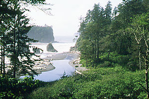 Follow the Hoh River to the Pacific, then drive along US 101 to Kalaloch; this stretch of the highway hugs the Pacific Coast, and offers some of the country's most dramatic ocean vistas. Access any number of wilderness beaches along the route - Ruby Beach, with its picturesque seastacks, is a favorite for photographers. Continue south to Queets, then east to Lake Quinault through the Quinault Indian Reservation. Taholah, on the coast, is the tribal center, but delicious native seafood products can be purchased at Quinault. Take the North Shore Road which follows along the lake, up the fertile Quinault River Valley, and eventually connects with the South Shore Road (it's unpaved at the upper reaches and not recommended for large RVs), which will take you back to the highway. Motorists can view yet another impressive temperate rain forest as they drive along the road, but to fully appreciate this unique environment, park the car, and explore it on foot. Some of the world's largest trees are found here, and the valley supports a diverse population of wildlife. Most of the trailheads are near the North Fork and Graves Creek Campgrounds, located off the loop route (watch for signs at the bridge approx. 15 miles in). The South Shore area also has a popular rain forest nature trail, and offers a variety of visitor amenities, including a store, bike rentals, and accommodations ranging from rustic cabins to the grand old Lake Quinault Lodge. Follow the Hoh River to the Pacific, then drive along US 101 to Kalaloch; this stretch of the highway hugs the Pacific Coast, and offers some of the country's most dramatic ocean vistas. Access any number of wilderness beaches along the route - Ruby Beach, with its picturesque seastacks, is a favorite for photographers. Continue south to Queets, then east to Lake Quinault through the Quinault Indian Reservation. Taholah, on the coast, is the tribal center, but delicious native seafood products can be purchased at Quinault. Take the North Shore Road which follows along the lake, up the fertile Quinault River Valley, and eventually connects with the South Shore Road (it's unpaved at the upper reaches and not recommended for large RVs), which will take you back to the highway. Motorists can view yet another impressive temperate rain forest as they drive along the road, but to fully appreciate this unique environment, park the car, and explore it on foot. Some of the world's largest trees are found here, and the valley supports a diverse population of wildlife. Most of the trailheads are near the North Fork and Graves Creek Campgrounds, located off the loop route (watch for signs at the bridge approx. 15 miles in). The South Shore area also has a popular rain forest nature trail, and offers a variety of visitor amenities, including a store, bike rentals, and accommodations ranging from rustic cabins to the grand old Lake Quinault Lodge.
Head south on US 101. Past Neilton watch for the Moclips Highway (Forest Road #2266), and drive west 5 miles to the Quinault National Fish Hatchery. In the fall adult salmon beging returning to their spawning grounds. The Visitor Center features exhibits about the Quinault Indian culture, the operation of the hatchery, and the overall role it plays in lives of people on the reservation. From here travelers can elect to continue west to SR 109 to explore miles of ocean beaches, and the seaside resort towns of Moclips, Pacific Beach, Copalis Beach, Ocean City, and Ocean Shores. Or, return to US 101 and proceed to Grays Harbor, a protected deep water harbor. The river town of Hoquiam offers a notable slice of Northwest history; stroll its 8th Street Landing and Waterfront Park, and don't miss the Polson Museum and Hoquiam Castle. The Grays Harbor estuary is one of the four major staging areas for shorebirds in North America - a critical refueling point for waterfowl migrating to and from their northern breeding grounds. Some years the numbers of birds that have stopped here have exceeded a million. These large flocks usually arrive in late April during their spring migration, then return between July and late October. Take SR 109 to Paulson Road, turn south, then west (adjacent to the Bowerman Field airport); watch for peregrine falcons, bald eagles, and merlins, too. Travel east on US 101 a few short miles to Aberdeen. At the turn of the century, this was a bustling seaport - the heart of Washington's booming timber industry. Tour the historic downtown district for a peek at its colorful past.
Take SR 105, to visit the South Beach area - dubbed the Cranberry Coast for its hundreds of acres of cranberry bogs. Stop at the cranberry museum in Grayland. Miles of ocean beaches offer months of sunny summer fun and exciting fall and winter storm watching opportunities. The seaside town of Westport is most popular for its spring whale watching and summer sportfishing charters, but the quiet off-season is also a wonderful time to explore this charming town. This is home to Washington's tallest lighthouse, a fascinating Maritime Museum, and restaurants that offer the freshest of seafood on their menus.
From Aberdeen drive east on US 12 to Elma. This delightful town, bedecked with historic murals, is also home to the Pacific Northwest Bigfoot Society Museum - a must for the curiosity seeker. Form here pick up SR 8 to McCleary, famous for its historic hotel. Take the SR 108 cutoff to US 101 heading north at Kamiche, just a few miles south of the lumber town of Shelton. Not far beyond the Skokomish River is the southern-most tip of the Hood Canal, a glacier-carved fjord that divides the Kitsap and Olympic Peninsulas. US 101 follows along a narrow corridor between the west bank of the Hood Canal and the eastern range of the Olympic Mountains that drops down to the water's edge; this is an especially beautiful drive, to say the least. It provides access to a number wilderness areas and backcountry trails.
Stop at the Hoodsport Winery, famous for its delicious fruit wines, right off the highway south of Hoodsport. This tiny village services touring motorists and visitors to Lake Cushman and the Staircase area of the National Park, located at the north end of the lake on the banks of the North Fork Skokomish River; trails take hikers along the river and through old-growth forests. The drive along the shoreline is very scenic, especially after it turns to gravel beyond the State Park.
Massive snowfields and glaciers high in the Olympic Mountains feed the major rivers along the eastern slopes; these plunge down short rocky courses before pouring into the Hood Canal. As you drive along the highway watch for signs that direct you up the river valleys of the Hamma Hamma, Duckabush, and Dosewallips. Their campgrounds close for the season in late fall, but trails from these areas are still accessible and venture deep into the high country - offering solitude and spectacular scenery even on short hikes. The Hood Canal is a popular recreation area, but it also provides habitat for salmon, clams, oysters, and shrimp. Large commercial oyster farms are centered around natural spawning grounds in Quilcene and Dabob Bays, but small growers are located all along the tidelands of the canal, and travelers can stop at outlets to purchase fresh or smoked oysters. A few miles north of the scenic town of Brinnon, stop at Seal Rock, the site of an ancient native camp and one of only a few campgrounds on National Forest lands located on saltwater. It is set on 47 acres of old-growth, and offers a unique look at interacting marine, intertidal, and forest ecosystems; a new interpretive trail elaborates on this delicate balance. Wildlife is abundant - watch for harbor seals, the marbled murrelet, and bald eagles.
Continue north on US 101 and watch for a sign to the Mt. Walker Lookout. A steep narrow gravel road climbs 4 miles to the mountain summit at 2,804' (not recommended for RVs). If the weather is bad, don't make this drive - it would be treacherous; the Forest Service will close it for the season during the first big storm in late fall. Otherwise, on a clear day, the view will be awesome. It gives a unique perspective of the Puget Sound region and its many waterways, stretching all the way from Mount Baker to Mount Rainier. The western vista looks back over the Olympic Mountains.
Port Gamble
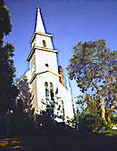 Further up the highway visit the Quilcene National Fish Hatchery. Chinook, chum, and silver salmon are reared and released here. Adults begin to return in late fall to spawn. From the town of Quilcene, take Center Road to SR 104; and head east across the Hood Canal Bridge. Follow the highway to Port Gamble; until recently this was the site of the oldest operating lumber mill in the United States - it shut down in early 1996. This historic company town is reminiscent of 1900th century New England; stop to stroll along its tree-lined walkways and to visit its museum. Continue on to the ferry landing in Kingston. If time allows, after lining up for the boat, get out and walk up to the nearby shops. They cater to travelers - great snacks, espresso, and exclusive Northwest merchandise. Further up the highway visit the Quilcene National Fish Hatchery. Chinook, chum, and silver salmon are reared and released here. Adults begin to return in late fall to spawn. From the town of Quilcene, take Center Road to SR 104; and head east across the Hood Canal Bridge. Follow the highway to Port Gamble; until recently this was the site of the oldest operating lumber mill in the United States - it shut down in early 1996. This historic company town is reminiscent of 1900th century New England; stop to stroll along its tree-lined walkways and to visit its museum. Continue on to the ferry landing in Kingston. If time allows, after lining up for the boat, get out and walk up to the nearby shops. They cater to travelers - great snacks, espresso, and exclusive Northwest merchandise.
Before heading out to I-5, stop in the picturesque town of Edmonds. Explore its waterfront beaches and downtown area. There are galleries, specialty boutiques, and many fine restaurants. To learn more about its fascinating past visit the Edmonds Historical Museum, housed in the Carnegie Library at 118 5th Ave. N.
When traveling on the Olympic Peninsula always bring protective clothing and rain gear, be prepared for sudden, and sometimes extreme, weather changes, and be beware of high surf and incoming tides on the beaches. For more information on Washington's National Wildlife Refuges and Fish Hatcheries refer to Flora and Fauna in our Outdoor Fun section. See the Olympic National Park listing under National Parks also in Outdoor Fun. Have a safe and fulfilling trip.
|
Washington's
TOP TEN "Must See"
Attractions
More Breathtaking
Top Destinations
Very Special Places
Accommodations At Some Best Of Washington Destinations.
Ferry Schedules
Traffic
Washington State
Travel Videos
Washington Skiing
& Winter Recreation
Pass Reports
|